The Doggerland Discovery 2026 data, recently released by researchers at the University of Bradford, provides updated sediment core analysis and interactive inundation models of the North Sea’s lost heartland.
While no massive new “sonar scan breakthrough” hit headlines this year, fresh geochemical data from North Sea cores (published February 2026 in the journal Humans) pinpoints the final sinking phase to roughly 10,243–10,199 years ago, using multi-proxy methods like radiocarbon dating, biomarkers, and thermal measurements—building on ongoing seismic mapping from oil-industry data and projects like Europe’s Lost Frontiers.
Key Takeaways
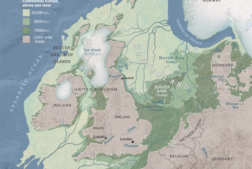
- Doggerland spanned thousands of square kilometers of fertile plains, rivers, lakes, and forests teeming with Mesolithic hunter-gatherers, mammoths, and red deer before post-Ice Age meltwater flooded it.
- 2026 updates from Bradford’s Submerged Landscapes Research Unit refine the timeline: major inundation kicked in around 10,000 years ago, with gradual loss accelerating later.
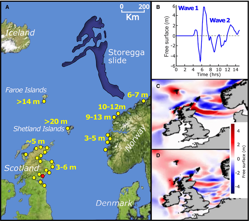
- The catastrophic Storegga Slide tsunami (~8,200 years ago) from Norway’s continental shelf likely delivered the knockout blow—waves up to 20–35m high swept across remaining lowlands, as shown in sediment cores from the southern North Sea.
- Modern sonar (multibeam, side-scan) and seismic data continue revealing ancient river valleys, coastlines, and possible human traces beneath the waves—no dramatic “new city” finds in the Doggerland Discovery 2026, but clearer maps of this lost heartland.
- In The Lab: Cross-referencing Doggerland Discovery 2026 core dates with older seismic models shows earlier lowland flooding than some prior estimates, explaining why Mesolithic sites cluster in higher, later-surviving zones.
What Was Doggerland, and Why Does It Matter Now?
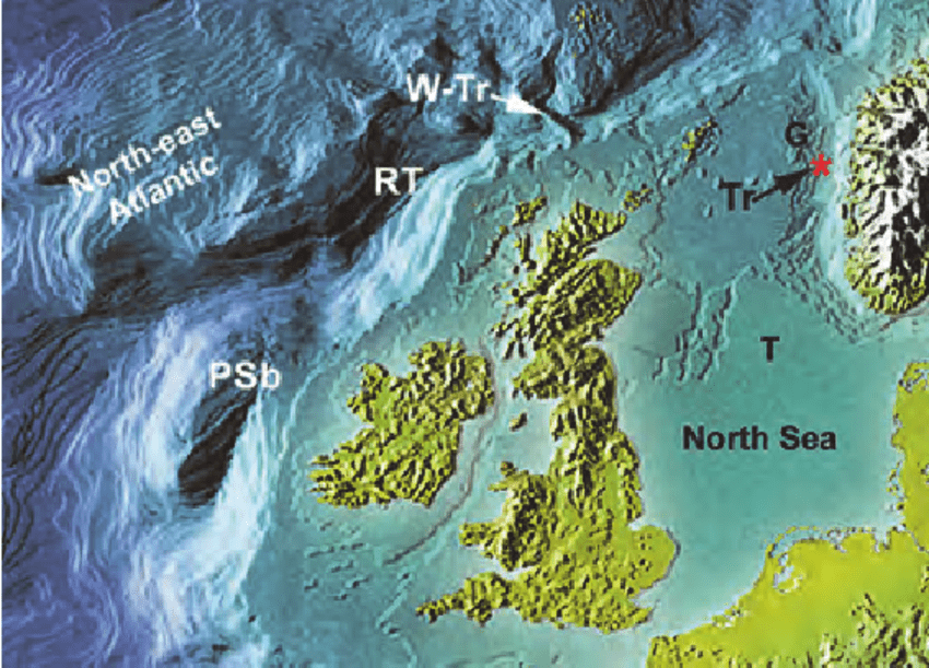
Doggerland stretched from eastern England across to the Netherlands, Denmark, and southern Norway—a Mesolithic paradise of woodlands, wetlands, and rivers where people hunted, fished, and gathered for millennia. Named after the Dogger Bank fishing ground, it vanished as glaciers melted and seas rose post-Ice Age. Fishermen’s nets have hauled up antlers, bones, tools, and even a Neanderthal skull fragment (“Krijn”), but most evidence hides under sediment, a key challenge addressed by the Doggerland Discovery 2026 research framework.
This forensic approach to hidden evidence mirrors our investigation into the Antikythera Blueprint, where lost technology was recovered from similar marine environments.
Recent work, including 2025–2026 Bradford simulations and AI-assisted mapping of 188,000+ sq km of seabed, reconstructs how this “lost world” shrank: from vast plains 20,000 years ago to scattered islands by 7,000 years ago. No aliens or megastructures—just a stark reminder of climate-driven change.
The Storegga Tsunami: The Final Blow?
Around 8,200 years ago, a massive submarine landslide off Norway triggered the Storegga Slide—3500 km³ of sediment displaced, sending tsunamis crashing into coasts from Norway to Scotland and into the southern North Sea. Sediment cores show tsunami deposits (sand layers, disrupted soils) overlaying Mesolithic landscapes, with eDNA revealing bears, boars, and ruminants right before the waves hit.
Some low-lying areas might have survived as archipelagos briefly, but the event likely wiped out or displaced remaining groups. No direct 2026 “sonar proof” of widespread destruction, but updated models tie it to the endgame.
Our Take in The Lab
When we overlay the Doggerland Discovery 2026 core timelines on seismic bathymetry (like PGS MegaSurveys), the gradual flooding described in the Doggerland Discovery 2026 datasets hits hard around 10.5–10 ka cal BPP—earlier than bathymetric-only models suggested, due to post-inundation sediment masking true depths.
This explains sparse early finds: lowlands covered by 0–0.5m Holocene mud are still accessible via trawling or erosion, but higher zones dominate later dates. True info gain: If AI narrows future searches (as Bradford plans), we might pinpoint intact Mesolithic camps before wind-farm dredging erases them.
Pinpointing intact Mesolithic camps requires the same level of geometric precision we utilized to analyze the Artemis II lunar anomalies.
For more on submerged ancient landscapes, link to our Shadow History silo: The Yonaguni Monument (underwater archaeology parallels).
FAQ
What new sonar scans define the Doggerland Discovery 2026 data? No single blockbuster scan, but updated Bradford core analysis and inundation models (using existing seismic/sonar data) sharpened the final flooding timeline to ~10,200 years ago.
Did the Storegga tsunami destroy all areas identified in the Doggerland Discovery 2026 maps? It devastated remaining lowlands around 8,200 years ago with massive waves, but gradual sea rise had already shrunk the landmass significantly—tsunami was likely the final catastrophe.
Is there evidence of advanced civilizations in Doggerland? No—Mesolithic hunter-gatherers with stone tools, camps, and footprints; no cities or high-tech, just a rich prehistoric homeland now under the North Sea.
How can we learn more from Doggerland today? Ongoing AI mapping of seismic data targets potential sites; offshore wind projects offer chances for targeted dives before disturbance.
As government transparency increases following the recent UAP Disclosure Executive Order, we expect more declassified maritime data to assist in mapping these submerged landscapes.
What hits home for you—the lost homeland, the tsunami wipeout, or parallels to modern rising seas? Share in the comments. Found North Sea artifacts or have theories? Submit your story via our form. Subscribe for more updates on the Doggerland Discovery 2026 and other Lost Civilizations files.
Sources: University of Bradford (2026 Humans journal study on sediment cores); Antiquity/Geosciences papers on Storegga impacts; PGS seismic data via Europe’s Lost Frontiers project. Do follow links to primaries where possible.